
West Belleville (Loyalist) Secondary Plan
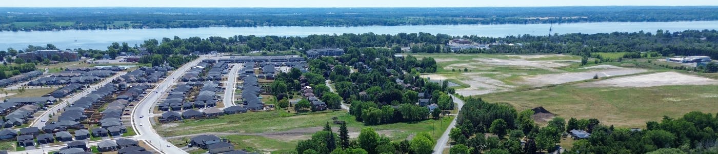
The City of Belleville is revising its Loyalist Secondary Plan, a long-term planning strategy for approximately 950 hectares of land east of Wallbridge‑Loyalist Road, south of Hwy 401, and north of the Bay of Quinte, to guide substantial future growth and development.
The plan will be rebranded as the West Belleville Secondary Plan and will shape a vibrant, sustainable mixed‑use community with:
- Over 11,400 new residential units spanning low-, medium-, and high-density formats;
- Enhanced transportation networks, parks, trails, and public infrastructure; and
- A balanced mix of commercial, employment, institutional, and recreational spaces.
A comprehensive suite of technical studies, including environmental, servicing, and traffic assessments, are underway to support policy refinements.
The update is being led by Dillon Consulting Limited and aligns with the City’s Official Plan, Provincial Planning Statement, and supporting strategies like the Infrastructure Phasing Strategy.
Key deliverables include:
- Revised land use concept and policy framework;
- Technical reports on servicing, transportation, natural heritage, flood mapping (Potter’s Creek); and
- Public engagement to ensure community insight shapes the Plan.
On May 11, 2026, Council approved the new West Belleville Secondary Plan (By-law 2026-66).
Next Steps:
City Staff will now focus on implementation strategies, which will include preparing necessary updates to Zoning By-law 2024-100 to ensure consistency with the new policies.
Stay Informed:
Stay informed and get involved in this important community project by visiting the City’s website and following this project page. You can subscribe for updates to be notified as the project reaches key milestones, request draft reports and mapping through the site, participate in upcoming public meetings (with details shared via this project page and mailing list).
-
Notice of Public Meeting
Share Notice of Public Meeting on Facebook Share Notice of Public Meeting on X (formerly Twitter) Share Notice of Public Meeting on Linkedin Email Notice of Public Meeting link
Who's Listening
-
Project Manager/Consultant

-

Email planning@belleville.ca -
Consultant

Project Documents
-
 Adopted West Belleville Secondary Plan (712 KB) (pdf)
-
West Belleville Secondary Plan Maps (1).pdf (30.4 MB) (pdf)
-
 Supporting Documents
-
WBSP Background Report (Mar 2026) (1.84 MB) (pdf)
-
Potters Creek Master Drainage Plan Implementation Report (Jan 2026) (40.1 MB) (pdf)
-
Transportation Assessment (Dec 2025) (14.6 MB) (pdf)
-
Four-Storey Study (Sep 2025) (5.22 MB) (pdf)
-
Natural Heritage Study Report (Jan 2023) (52.8 MB) (pdf)
-
Interim Report (Jul 2022) (4.72 MB) (pdf)
-
-
Public Consultation
-
Public Consultation Centre 1 - What We Heard (327 KB) (pdf)
-
Public Consultation Centre 1 - Display Boards (2.56 MB) (pdf)
-
Public Consultation Centre 2 - What We Heard (2.99 MB) (pdf)
-
Public Consultation Centre 2 - Display Boards (3.39 MB) (pdf)
-
Public Consultation Centre Display Boards (Oct 2025) (7.95 MB) (pdf)
-
Notice of Public Notice.pdf (100 KB) (pdf)
-
Public Meeting Presentation - Dillon Consulting (April 7 2026) (6.75 MB) (pdf)
-


FAQs
-
Project FAQ
- Why is the density of development changing – we thought there was a plan for the Loyalist West area already?
- How much traffic is there going to be in this area given all the new development?
- Why can’t we develop in the floodplain? Have you used the latest techniques to assess the extent of the floodplain?
- Is there sufficient infrastructure – water, sanitary sewer, and storm sewer – to support all the growth? And how expensive will it be?
- What qualifies as a “natural area” or “natural habitat”?
- If there is high rise development being considered, how “high” is high rise?